River Great Stour — Río Great Stour (River Great Stour) Mapa del River Stour y sus afluentes. País que atraviesa … Wikipedia Español
Durango and Silverton Narrow Gauge Railroad — Durango Silverton Narrow Gauge Railroad Locale La Plata County and San Juan County, Colorado Dates of operation 1881–present Track gauge … Wikipedia
West Virginia Route 29 — Infobox road state=WV type=WV route=29 length mi=69.3 length round=1 length ref=Distance calculated using Microsoft MapPoint mapping software.] established= direction a=South starting terminus= junction=jct|state=WV|US|50 concurrent near Pleasant … Wikipedia
Cumbres and Toltec Scenic Railroad — Cumbres Toltec Scenic Railroad Locale Conejos County and Archuleta County in Colorado and Rio Arriba County in New Mexico Dates o … Wikipedia
Railroad switch — For other uses, see Switch (disambiguation). A right hand railroad switch with point indicator pointing to right … Wikipedia
United States — a republic in the N Western Hemisphere comprising 48 conterminous states, the District of Columbia, and Alaska in North America, and Hawaii in the N Pacific. 267,954,767; conterminous United States, 3,022,387 sq. mi. (7,827,982 sq. km); with… … Universalium
Hereford — Para otros usos de este término, véase Hereford (desambiguación). Catedral de Hereford y puente sobre el Wye. Hereford es una ciudad, sede episcopal, parroquia y county town de Herefordshire, en la región de los Midlands del Oeste (Ingl … Wikipedia Español
Louisa Anne Meredith — Solanum aviculare. Litografía coloreada impresa de su obra Bush Friends in Tasmania … Wikipedia Español
Glossary of rail terminology — Rail transport Operations Track Maintenance High speed Gauge Stations … Wikipedia
List of enclaves and exclaves — In political geography, an enclave is a piece of land which is totally surrounded by a foreign territory, and an exclave is one which is politically attached to a larger piece but not actually contiguous with it. Many entities are both enclaves… … Wikipedia
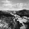 Curso serpenteado del río Wye a su paso por Symonds Yat, Hereford y Worcester, Gales, Reino ...G.F. AllenBruce Coleman Inc.